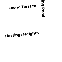
24 HASTINGS HEIGHTS
Owner Information
WALKER JEANETTE & SIMON MARK
24 HASTINGS HEIGHTS
FLORENCE, MA 01062


Property Details
24 HASTINGS HEIGHTS is classified as a Single Family Residential (2).
The primary structure on this property was built in 1963. There are 1,240ft2 of built area within this property. There is 1,240ft2 of residential/living space within this property. This property is listed as having 6 rooms.
24 HASTINGS HEIGHTS is valued at $237,100. The land is valued at $105,900 and the structures are valued at $131,200.
24 HASTINGS HEIGHTS was last sold on Friday, January 18, 2008 for $220,000.
Assessment data from fiscal year 2020.
Flood Data
According to the FEMA National Flood Hazard Layer, this property does not appear to be in a flood zone. It may also be in an area not yet reviewed. Nonetheless, confirm this information prior to taking any action.
To view the flood hazards around this property, create a FEMA "Firmette" Map of the area around 24 HASTINGS HEIGHTS.
Broadband Internet Providers
| Provider | Type | Bandwidth (mbps) | |
|---|---|---|---|
| GCI Communication Corp. | Satellite | 0 | 0 |
| T-Mobile | Fixed Wireless | 25 | 3 |
| Comcast | Cable | 1000 | 35 |
| Verizon New England Inc. | DSL | 5 | 0 |
| Viasat Inc | Satellite | 100 | 3 |
| VSAT Systems, LLC. | Satellite | 2 | 1 |
| HughesNet | Satellite | 25 | 3 |
Broadband service provider data from December 2020.
Adjacent Properties
- 14 HASTINGS HEIGHTS
Single Family Residential owned by KULP JASON M & MOHINI S KULP - 15 LEENO TERR
Single Family Residential owned by ZIDIK JOSEPH & ROBERTA M - 23 LEENO TERR
Single Family Residential owned by SKOWRON JEFFREY & SUSAN MAYHEW - 34 HASTINGS HEIGHTS
Single Family Residential owned by QUACKENBUSH RICHARD M - 31 LEENO TERR
Single Family Residential owned by RYAN-WISE MAUREEN